Geolocate

Wheatland topographic map

Click on the map to display elevation.

About this map

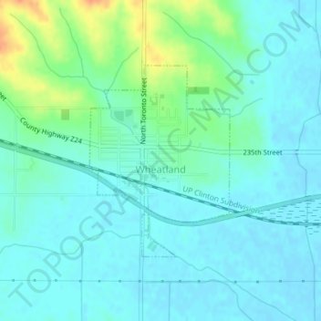
Name: Wheatland topographic map, elevation, terrain.

Location: Wheatland, Clinton County, Iowa, United States (41.82432 -90.84625 41.84041 -90.83041)

Average elevation: 699 ft

Minimum elevation: 666 ft

Maximum elevation: 804 ft

Clinton County trails, hiking, mountain biking, running and outdoor activities

Gear up for your next adventure:

📻Weather Alert Radios - Stay informed of storm risks while off-the-grid
🚗GPS Dash Cams - Record your scenic drives through mountain passes and canyons
🧭Compass with Lanyard - Easy‑carry compass for navigation
🥄Camping Utensil Set - Lightweight utensils for outdoor meals
🥾Hiking Shoes - Durable and comfortable shoes for trail hiking

As an Amazon Associate, this site earns from qualifying purchases at no extra cost to you.