Geolocate

Malvan topographic map

Click on the map to display elevation.

About this map

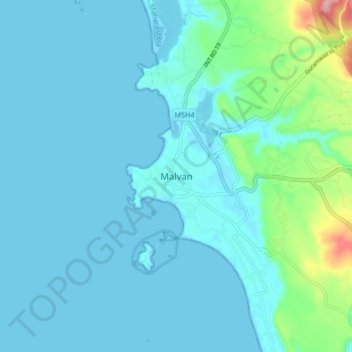
Name: Malvan topographic map, elevation, terrain.

Location: Malvan, Malvan Taluka, Sindhudurg, Maharashtra, 416606, India (16.02064 73.42695 16.10064 73.50695)

Average elevation: 66 ft

Minimum elevation: 0 ft

Maximum elevation: 502 ft

Other topographic maps

Click on a map to view its topography, its elevation and its terrain.

Dikwal

India > Maharashtra > Malvan Taluka

Average elevation: 338 ft

Tarkarli beach

India > Maharashtra > Malvan Taluka > Tarkarli

Average elevation: 36 ft

Gear up for your next adventure:

🦺Reflective Outdoor Gear - Safety gear for low‑light conditions
🪶Trail Camera - Capture wildlife on your hikes
📡GPS Antenna Upgrade - Enhance GPS reception in remote terrain
GPS Sports Watch - GPS watch for running, hiking and training
🗺️NatGeo Topo Maps - High-quality waterproof printed topographic maps of US Parks

As an Amazon Associate, this site earns from qualifying purchases at no extra cost to you.