
Thank you for supporting this site ❤️
Make a donation
Make a donation
Gear up for your next adventure:
As an Amazon Associate, this site earns from qualifying purchases at no extra cost to you.
Halden topographic map
Click on the map to display elevation.
Thank you for supporting this site ❤️
Make a donation
Make a donation
Gear up for your next adventure:
As an Amazon Associate, this site earns from qualifying purchases at no extra cost to you.
About this map
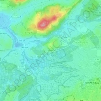
Name: Halden topographic map, elevation, terrain.
Average elevation: 2,283 ft
Minimum elevation: 2,172 ft
Maximum elevation: 2,667 ft
Thank you for supporting this site ❤️
Make a donation
Make a donation
Gear up for your next adventure:
As an Amazon Associate, this site earns from qualifying purchases at no extra cost to you.
Other topographic maps
Click on a map to view its topography, its elevation and its terrain.
Neutrauchburg
Deutschland > Baden-Württemberg > Landkreis Ravensburg > Isny im Allgäu
Average elevation: 2,359 ft
Badsee
Deutschland > Baden-Württemberg > Landkreis Ravensburg > Isny im Allgäu > Beuren > Seehalden
Average elevation: 2,320 ft