Geolocate

Skelmorlie topographic map

Click on the map to display elevation.

About this map

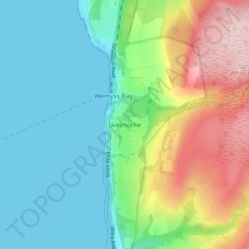
Name: Skelmorlie topographic map, elevation, terrain.

Location: Skelmorlie, North Ayrshire, Scotland, PA17 5AQ, United Kingdom (55.85134 -4.90541 55.89134 -4.86541)

Average elevation: 223 ft

Minimum elevation: 0 ft

Maximum elevation: 702 ft

Gear up for your next adventure:

🩳Quick‑Dry Hiking Shorts - Comfortable and quick‑dry shorts for summer hiking
🏕️Family Camping Gear - Essentials for group camping trips
🎒Day Hiking Backpack - Lightweight backpack perfect for day trips and outdoor adventures
☀️Outdoor Sunscreen - High protection sunscreen for outdoor activities
👟Men's Trail Runners - Lightweight footwear for fast-paced exploration and light hiking

As an Amazon Associate, this site earns from qualifying purchases at no extra cost to you.