Geolocate

Ragay topographic map

Click on the map to display elevation.

About this map

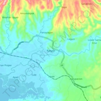
Name: Ragay topographic map, elevation, terrain.

Location: Ragay, Camarines Sur, Bicol Region, 4409, Philippines (13.78106 122.74763 13.86106 122.82763)

Average elevation: 167 ft

Minimum elevation: -7 ft

Maximum elevation: 715 ft

Other topographic maps

Click on a map to view its topography, its elevation and its terrain.

Del Gallego

Philippines > Camarines Sur

Average elevation: 299 ft

Sagñay

Philippines > Camarines Sur

Average elevation: 535 ft

Caramoan

Philippines > Camarines Sur

Average elevation: 138 ft

Gear up for your next adventure:

🗃️Trail First Aid Kit - Essential kit for outdoor injuries and emergencies
🌡️Portable Weather Meter - Track weather conditions on the trail
🧤Tactile Hiking Gloves - Keep hands warm while operating GPS and smartphone screens
🔪Outdoor Multitools - Essential survival tools for gear repair and field use
🚑Emergency Bivvies - Heat-reflective sleeping bags for survival situations

As an Amazon Associate, this site earns from qualifying purchases at no extra cost to you.