
Make a donation
Gear up for your next adventure:
As an Amazon Associate, this site earns from qualifying purchases at no extra cost to you.
Moundou topographic map
Click on the map to display elevation.
Make a donation
Gear up for your next adventure:
As an Amazon Associate, this site earns from qualifying purchases at no extra cost to you.
Moundou
The first cadastral map of the town of Moundou was manufactured on 2 February 1926. Since there were not, at the time, the materials for substantial topographical surveys, the drainage pipeline of the town was facing the river in the belief that the natural inclination would head toward the river, when in reality the river level is higher than the level of the city. In 2012, the mayor of Moundou, Laoukein Kourayo Médard, said that "every time there was a flood, all the waters of the Logone discharged to Lake Wey (in the West), which in turn sprays its water into the city, flooding Moundou entirely."
Make a donation
Gear up for your next adventure:
As an Amazon Associate, this site earns from qualifying purchases at no extra cost to you.
About this map
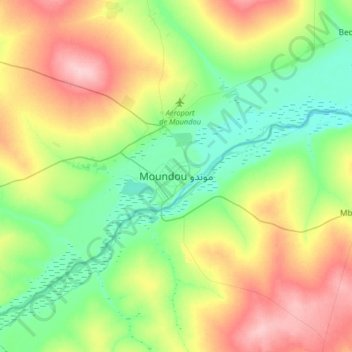
Name: Moundou topographic map, elevation, terrain.
Location: Moundou, Logone Occidental, Chad (8.40546 15.91383 8.72546 16.23383)
Average elevation: 1,437 ft
Minimum elevation: 1,257 ft
Maximum elevation: 1,745 ft
Make a donation
Gear up for your next adventure:
As an Amazon Associate, this site earns from qualifying purchases at no extra cost to you.