
Make a donation
Gear up for your next adventure:
As an Amazon Associate, this site earns from qualifying purchases at no extra cost to you.
Buckenhofen topographic map
Click on the map to display elevation.
Make a donation
Gear up for your next adventure:
As an Amazon Associate, this site earns from qualifying purchases at no extra cost to you.
Buckenhofen
Das Pfarrdorf in der naturräumlichen Landschaftseinheit des Regnitztals liegt etwa eineinhalb Kilometer nordwestlich des Ortszentrums von Forchheim auf einer Höhe von 268 m ü. NHN. Der Ort ist mit dem Siedlungsgebiet des südlich gelegenen Nachbarortes Burk zusammengewachsen.
Make a donation
Gear up for your next adventure:
As an Amazon Associate, this site earns from qualifying purchases at no extra cost to you.
About this map
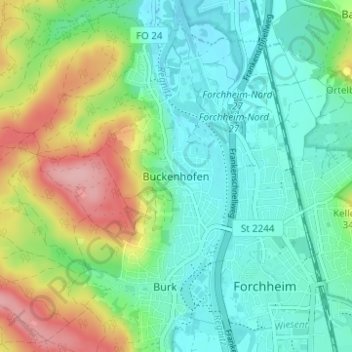
Name: Buckenhofen topographic map, elevation, terrain.
Average elevation: 955 ft
Minimum elevation: 820 ft
Maximum elevation: 1,257 ft
Make a donation
Gear up for your next adventure:
As an Amazon Associate, this site earns from qualifying purchases at no extra cost to you.