
Los Ríos topographic map
Interactive map
Click on the map to display elevation.
About this map
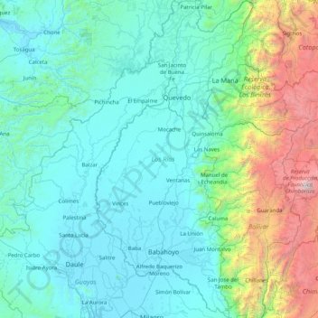
Name: Los Ríos topographic map, elevation, terrain.
Location: Los Ríos, Ecuador (-2.13305 -79.87754 -0.53742 -79.08156)
Average elevation: 2,753 ft
Minimum elevation: -7 ft
Maximum elevation: 20,463 ft
Other topographic maps
Click on a map to view its topography, its elevation and its terrain.
Las Tres Marias
Ecuador > Los Ríos > Montalvo > Montalvo > Las Tres Marias
Las Tres Marias, Montalvo, Los Ríos, Ecuador
Average elevation: 23 ft
Bella Union
Ecuador > Los Ríos > Bella Union
Bella Union, Cantón Quinsaloma, Los Ríos, Ecuador
Average elevation: 282 ft