
Make a donation
Gear up for your next adventure:
As an Amazon Associate, this site earns from qualifying purchases at no extra cost to you.
Braunwald topographic map
Click on the map to display elevation.
Make a donation
Gear up for your next adventure:
As an Amazon Associate, this site earns from qualifying purchases at no extra cost to you.
Braunwald
Braunwald is situated in the Glarus Alps on a terrace above the Linth valley, at an elevation of 1,256 meters (4,121 ft). It overlooks the villages of Linthal and Rüti in the valley below. It is overlooked by the mountains of Ortstock (2,717 m or 8,914 ft), Höch Turm (2,666 m or 8,747 ft), Eggstock (2,455 m or 8,054 ft) and Bös Fulen (2,802 m or 9,193 ft).
Make a donation
Gear up for your next adventure:
As an Amazon Associate, this site earns from qualifying purchases at no extra cost to you.
About this map
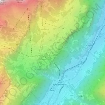
Name: Braunwald topographic map, elevation, terrain.
Location: Braunwald, Glarus Süd, Glarus, 8784, Switzerland (46.91926 8.97850 46.95926 9.01850)
Average elevation: 3,986 ft
Minimum elevation: 1,929 ft
Maximum elevation: 7,871 ft
Make a donation
Gear up for your next adventure:
As an Amazon Associate, this site earns from qualifying purchases at no extra cost to you.
Other topographic maps
Click on a map to view its topography, its elevation and its terrain.