
Make a donation
Gear up for your next adventure:
As an Amazon Associate, this site earns from qualifying purchases at no extra cost to you.
Vinhais topographic map
Click on the map to display elevation.
Make a donation
Gear up for your next adventure:
As an Amazon Associate, this site earns from qualifying purchases at no extra cost to you.
Vinhais
It is perched on the slopes of the Coroa mountains at an altitude of approximately 600 meters, protected from the cold winds of the north by the Ciradelha mountain, where in remote times there was a Luso-Roman castro. On the south side is the Tuela River valley. There are three other rivers in the concelho: the Rabaçal, the Mente, and the Baceiro. They are relatively unpolluted and provide fish for locals and tourists. The Baceiro has a trout hatchery which is deactivated but will be reopened soon.
Make a donation
Gear up for your next adventure:
As an Amazon Associate, this site earns from qualifying purchases at no extra cost to you.
About this map
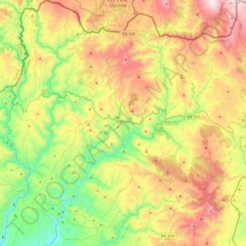
Name: Vinhais topographic map, elevation, terrain.
Location: Vinhais, Bragança, Portugal (41.67113 -7.21360 41.99076 -6.86096)
Average elevation: 2,556 ft
Minimum elevation: 846 ft
Maximum elevation: 5,010 ft
Make a donation
Gear up for your next adventure:
As an Amazon Associate, this site earns from qualifying purchases at no extra cost to you.
Other topographic maps
Click on a map to view its topography, its elevation and its terrain.
Make a donation
Gear up for your next adventure:
As an Amazon Associate, this site earns from qualifying purchases at no extra cost to you.