Geolocate
👉 Easily get elevation data in JSON, GeoTIFF and KML formats using Elevation API
Thank you for supporting this site ❤️
Make a donation

Moberly topographic map

Click on the map to display elevation.

About this map

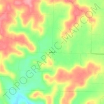
Name: Moberly topographic map, elevation, terrain.

Location: Moberly, Harrison County, Indiana, United States (38.24979 -86.22942 38.28979 -86.18942)

Average elevation: 673 ft

Minimum elevation: 489 ft

Maximum elevation: 837 ft

Harrison County trails, hiking, mountain biking, running and outdoor activities

Other topographic maps

Click on a map to view its topography, its elevation and its terrain.

New Amsterdam

United States > Indiana > Harrison County

Average elevation: 495 ft

New Middletown

United States > Indiana > Harrison County

Average elevation: 705 ft

Crandall

United States > Indiana > Harrison County

Average elevation: 712 ft

Laconia

United States > Indiana > Harrison County

Average elevation: 659 ft

Gear up for your next adventure:

🏔️Mountain Trail Maps - High‑detail maps for popular peaks
🔋Rechargeable Batteries - Power up your outdoor devices
🪶Fire Starter Kit - Reliable fire starter for survival and camping
📶Satellite Messenger - Communication device off‑grid
🧦Hiking Socks - Comfortable socks to prevent blisters on long hikes

As an Amazon Associate, this site earns from qualifying purchases at no extra cost to you.