
Make a donation
Gear up for your next adventure:
As an Amazon Associate, this site earns from qualifying purchases at no extra cost to you.
El Rubio topographic map
Click on the map to display elevation.
Make a donation
Gear up for your next adventure:
As an Amazon Associate, this site earns from qualifying purchases at no extra cost to you.
About this map
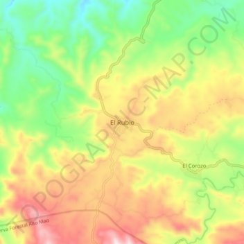
Name: El Rubio topographic map, elevation, terrain.
Average elevation: 1,509 ft
Minimum elevation: 650 ft
Maximum elevation: 2,549 ft
Make a donation
Gear up for your next adventure:
As an Amazon Associate, this site earns from qualifying purchases at no extra cost to you.
Other topographic maps
Click on a map to view its topography, its elevation and its terrain.
Santiago de los Caballeros
Santiago de los Caballeros (Spanish pronunciation: [sanˈtjaɣo ðe los kaβaˈʝeɾos]; English: Saint James of the Knights), often shortened to Santiago, is the second-largest city in the Dominican Republic and the fourth-largest city in the Caribbean by population. It is the capital of Santiago Province and…
Average elevation: 1,119 ft