Geolocate

New Castle topographic map

Click on the map to display elevation.

About this map

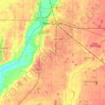
Name: New Castle topographic map, elevation, terrain.

Location: New Castle, Henry County, Indiana, 47362, United States (39.85573 -85.41013 39.94954 -85.33762)

Average elevation: 1,060 ft

Minimum elevation: 948 ft

Maximum elevation: 1,115 ft

Henry County trails, hiking, mountain biking, running and outdoor activities

Other topographic maps

Click on a map to view its topography, its elevation and its terrain.

Messick

United States > Indiana > Henry County

Average elevation: 1,096 ft

Westwood

United States > Indiana > Henry County

Average elevation: 1,047 ft

Gear up for your next adventure:

📷Action Camera - Capture your outdoor adventures in HD
🧤Hiking Gloves - Protective gloves for rugged trails
🧭Orienteering Set - Complete compass and map reading kit
🏕️Family Camping Gear - Essentials for group camping trips
🌡️Portable Weather Meter - Track weather conditions on the trail

As an Amazon Associate, this site earns from qualifying purchases at no extra cost to you.