
Make a donation
Gear up for your next adventure:
As an Amazon Associate, this site earns from qualifying purchases at no extra cost to you.
Menzingen topographic map
Click on the map to display elevation.
Make a donation
Gear up for your next adventure:
As an Amazon Associate, this site earns from qualifying purchases at no extra cost to you.
Menzingen
The municipality is located on a moraine plateau between the Lorze and Sihl rivers at an elevation of about 800 m (2,600 ft). In 1848 the municipality of Neuheim separated from Menzingen. It consists of the village of Menzingen and a number of hamlets and individual farm houses.
Make a donation
Gear up for your next adventure:
As an Amazon Associate, this site earns from qualifying purchases at no extra cost to you.
About this map
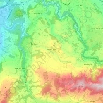
Name: Menzingen topographic map, elevation, terrain.
Location: Menzingen, Zug, 6313, Switzerland (47.14806 8.55440 47.20524 8.66577)
Average elevation: 2,428 ft
Minimum elevation: 1,453 ft
Maximum elevation: 3,921 ft
Make a donation
Gear up for your next adventure:
As an Amazon Associate, this site earns from qualifying purchases at no extra cost to you.
Other topographic maps
Click on a map to view its topography, its elevation and its terrain.
Make a donation
Gear up for your next adventure:
As an Amazon Associate, this site earns from qualifying purchases at no extra cost to you.