
Make a donation
Gear up for your next adventure:
As an Amazon Associate, this site earns from qualifying purchases at no extra cost to you.
Araitz topographic map
Click on the map to display elevation.
Make a donation
Gear up for your next adventure:
As an Amazon Associate, this site earns from qualifying purchases at no extra cost to you.
About this map
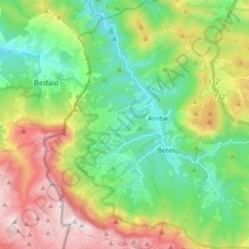
Name: Araitz topographic map, elevation, terrain.
Location: Araitz, Larraun-Leitzaldea, Navarre, 31891, Espagne (42.98975 -2.04124 43.07980 -1.96080)
Average elevation: 2,041 ft
Minimum elevation: 561 ft
Maximum elevation: 4,659 ft
Make a donation
Gear up for your next adventure:
As an Amazon Associate, this site earns from qualifying purchases at no extra cost to you.
Other topographic maps
Click on a map to view its topography, its elevation and its terrain.
Lekunberri
Espagne > Navarre > Larraun-Leitzaldea > Lekunberri > Lekunberri
Average elevation: 2,064 ft
Make a donation
Gear up for your next adventure:
As an Amazon Associate, this site earns from qualifying purchases at no extra cost to you.