
Thank you for supporting this site ❤️
Make a donation
Make a donation
Gear up for your next adventure:
As an Amazon Associate, this site earns from qualifying purchases at no extra cost to you.
Monte Ciocci topographic map
Click on the map to display elevation.
Thank you for supporting this site ❤️
Make a donation
Make a donation
Gear up for your next adventure:
As an Amazon Associate, this site earns from qualifying purchases at no extra cost to you.
About this map
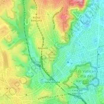
Name: Monte Ciocci topographic map, elevation, terrain.
Location: Monte Ciocci, Roma, Lazio, 00136, Italia (41.90995 12.44203 41.91005 12.44213)
Average elevation: 210 ft
Minimum elevation: 49 ft
Maximum elevation: 456 ft
Thank you for supporting this site ❤️
Make a donation
Make a donation
Gear up for your next adventure:
As an Amazon Associate, this site earns from qualifying purchases at no extra cost to you.
Other topographic maps
Click on a map to view its topography, its elevation and its terrain.
Monumento Naturale di Galeria Antica
Italia > Lazio > Roma > Roma > Osteria Nuova > Santa Maria di Galeria
Average elevation: 397 ft