Geolocate
👉 Easily get elevation data in JSON, GeoTIFF and KML formats using Elevation API
Thank you for supporting this site ❤️
Make a donation

Trust topographic map

Click on the map to display elevation.

About this map

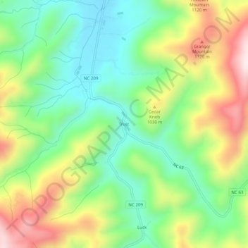
Name: Trust topographic map, elevation, terrain.

Location: Trust, Madison County, North Carolina, United States (35.73260 -82.88986 35.77260 -82.84986)

Average elevation: 2,966 ft

Minimum elevation: 2,247 ft

Maximum elevation: 4,098 ft

Madison County trails, hiking, mountain biking, running and outdoor activities

Gear up for your next adventure:

🪶Camping Sleeping Pad - Comfortable sleeping pad for backpacking
🔭Stargazing Telescopes - Perfect for camping in low-light pollution areas shown on maps
🧴Hand Sanitizer - Keep hands clean while hiking
🚪Portable Camp Chair - Foldable chair for comfort at camp
🦶Carbon Trekking Poles - Reduce knee impact on steep descents with ultra-light poles

As an Amazon Associate, this site earns from qualifying purchases at no extra cost to you.