
Make a donation
Gear up for your next adventure:
As an Amazon Associate, this site earns from qualifying purchases at no extra cost to you.
Recoletos topographic map
Click on the map to display elevation.
Make a donation
Gear up for your next adventure:
As an Amazon Associate, this site earns from qualifying purchases at no extra cost to you.
About this map
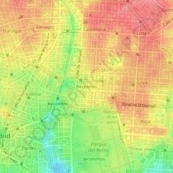
Name: Recoletos topographic map, elevation, terrain.
Average elevation: 2,231 ft
Minimum elevation: 2,070 ft
Maximum elevation: 2,329 ft
Make a donation
Gear up for your next adventure:
As an Amazon Associate, this site earns from qualifying purchases at no extra cost to you.
Other topographic maps
Click on a map to view its topography, its elevation and its terrain.
Madrid
Espagne > Communauté de Madrid > Madrid
Très proche du centre géographique de la péninsule Ibérique, la colline des Anges (Cerro de los Ángeles), à environ 50 km au sud de la Sierra de Guadarrama, la ville s'étend sur le plateau de la Meseta entre 600 et 700 m au-dessus du niveau de la mer. Située à une altitude de 657 m, Madrid est la…
Average elevation: 2,133 ft