
Thank you for supporting this site ❤️
Make a donation
Make a donation
Gear up for your next adventure:
As an Amazon Associate, this site earns from qualifying purchases at no extra cost to you.
Edelburg topographic map
Click on the map to display elevation.
Thank you for supporting this site ❤️
Make a donation
Make a donation
Gear up for your next adventure:
As an Amazon Associate, this site earns from qualifying purchases at no extra cost to you.
Edelburg
Die Edelburg ist eine Hofanlage im Norden Hemers, die gemeinsam mit dem benachbarten Gebäudekomplex einen Ortsteil der Stadt bildet. Die Anlage liegt an der Oese nahe der Stadtgrenze zu Menden auf einer Höhe von 167 Metern.
Thank you for supporting this site ❤️
Make a donation
Make a donation
Gear up for your next adventure:
As an Amazon Associate, this site earns from qualifying purchases at no extra cost to you.
About this map
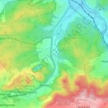
Name: Edelburg topographic map, elevation, terrain.
Average elevation: 702 ft
Minimum elevation: 472 ft
Maximum elevation: 1,102 ft
Thank you for supporting this site ❤️
Make a donation
Make a donation
Gear up for your next adventure:
As an Amazon Associate, this site earns from qualifying purchases at no extra cost to you.