
Thank you for supporting this site ❤️
Make a donation
Make a donation
Gear up for your next adventure:
As an Amazon Associate, this site earns from qualifying purchases at no extra cost to you.
鹧鸪山 topographic map
Click on the map to display elevation.
Thank you for supporting this site ❤️
Make a donation
Make a donation
Gear up for your next adventure:
As an Amazon Associate, this site earns from qualifying purchases at no extra cost to you.
About this map
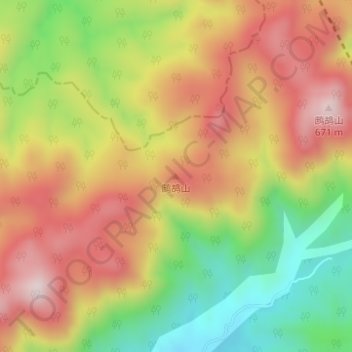
Name: 鹧鸪山 topographic map, elevation, terrain.
Location: 鹧鸪山, Taizhou, 花前产业园区, Zhejiang, China (29.23848 120.88350 29.23858 120.88360)
Average elevation: 1,388 ft
Minimum elevation: 541 ft
Maximum elevation: 2,139 ft
Thank you for supporting this site ❤️
Make a donation
Make a donation
Gear up for your next adventure:
As an Amazon Associate, this site earns from qualifying purchases at no extra cost to you.