
Make a donation
Gear up for your next adventure:
As an Amazon Associate, this site earns from qualifying purchases at no extra cost to you.
Paposo topographic map
Click on the map to display elevation.
Make a donation
Gear up for your next adventure:
As an Amazon Associate, this site earns from qualifying purchases at no extra cost to you.
Paposo
Aproximadamente a una elevación de 400 - 700 m. se produce el centro de la diversidad de especies en el área. La especie dominante es Euphorbia lactiflua que se presenta frecuentemente con Lycopersicon chilense. En la parte superior de esta zona se encuentran en abundancia Schizanthus laetus y Alstroemeria violacea, Chaetanthera glabrata, Ephedra, Proustia. Arriba de los 700 m. y coincidiendo con el límite superior de la neblina, se presentan los cactus Copiapoa y una de las especies más ryesistentes a la sequía: Loasa fruticosa. Junto con Chuquiraga ulicina forma el límite superior de la vegetación. También se puede encontrar diferentes especies, como Dinemagonum gayanum, Cruckshanksia pumila, Oxalis y michay de Paposo (Berberis litoralis).
Make a donation
Gear up for your next adventure:
As an Amazon Associate, this site earns from qualifying purchases at no extra cost to you.
About this map
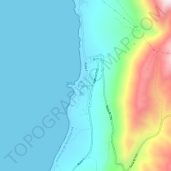
Name: Paposo topographic map, elevation, terrain.
Average elevation: 581 ft
Minimum elevation: -3 ft
Maximum elevation: 2,785 ft
Make a donation
Gear up for your next adventure:
As an Amazon Associate, this site earns from qualifying purchases at no extra cost to you.