
Thank you for supporting this site ❤️
Make a donation
Make a donation
Gear up for your next adventure:
As an Amazon Associate, this site earns from qualifying purchases at no extra cost to you.
Wiler topographic map
Click on the map to display elevation.
Thank you for supporting this site ❤️
Make a donation
Make a donation
Gear up for your next adventure:
As an Amazon Associate, this site earns from qualifying purchases at no extra cost to you.
About this map
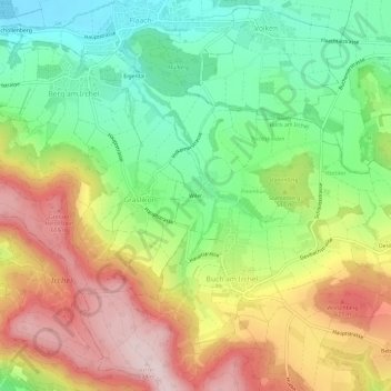
Name: Wiler topographic map, elevation, terrain.
Location: Wiler, Buch am Irchel, Bezirk Andelfingen, Zürich, 8414, Schweiz (47.53749 8.59444 47.57749 8.63444)
Average elevation: 1,647 ft
Minimum elevation: 1,119 ft
Maximum elevation: 2,300 ft
Thank you for supporting this site ❤️
Make a donation
Make a donation
Gear up for your next adventure:
As an Amazon Associate, this site earns from qualifying purchases at no extra cost to you.