
Make a donation
Gear up for your next adventure:
As an Amazon Associate, this site earns from qualifying purchases at no extra cost to you.
Torreya State Park topographic map
Click on the map to display elevation.
Make a donation
Gear up for your next adventure:
As an Amazon Associate, this site earns from qualifying purchases at no extra cost to you.
Torreya State Park
With river swamps and high pinelands, extensive ravines and high bluffs along the river, the park has one of the most variable terrains of any in Florida. The high elevation of the park is about 300 feet at the top of Logan Hill. Many streams run through the park.
Make a donation
Gear up for your next adventure:
As an Amazon Associate, this site earns from qualifying purchases at no extra cost to you.
About this map
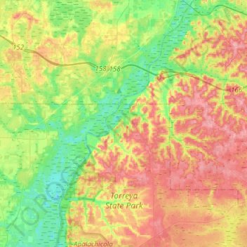
Name: Torreya State Park topographic map, elevation, terrain.
Location: Torreya State Park, Liberty County, Florida, United States (30.48402 -84.97138 30.69425 -84.86137)
Average elevation: 154 ft
Minimum elevation: 20 ft
Maximum elevation: 308 ft
Liberty County trails, hiking, mountain biking, running and outdoor activities
Make a donation
Gear up for your next adventure:
As an Amazon Associate, this site earns from qualifying purchases at no extra cost to you.