
Thank you for supporting this site ❤️
Make a donation
Make a donation
Gear up for your next adventure:
As an Amazon Associate, this site earns from qualifying purchases at no extra cost to you.
Mathira topographic map
Click on the map to display elevation.
Thank you for supporting this site ❤️
Make a donation
Make a donation
Gear up for your next adventure:
As an Amazon Associate, this site earns from qualifying purchases at no extra cost to you.
About this map
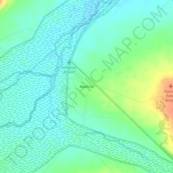
Name: Mathira topographic map, elevation, terrain.
Location: Mathira, Laikipia West, Laikipia County, Rift Valley, Kenya (0.31046 36.61126 0.35046 36.65126)
Average elevation: 5,902 ft
Minimum elevation: 5,863 ft
Maximum elevation: 5,997 ft
Thank you for supporting this site ❤️
Make a donation
Make a donation
Gear up for your next adventure:
As an Amazon Associate, this site earns from qualifying purchases at no extra cost to you.