
Phetchabun topographic map
Interactive map
Click on the map to display elevation.
About this map
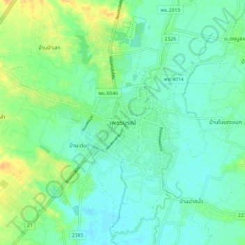
Name: Phetchabun topographic map, elevation, terrain.
Location: Phetchabun, Phetchabun Province, 67000, Thailand (16.37803 101.11568 16.45803 101.19568)
Average elevation: 394 ft
Minimum elevation: 361 ft
Maximum elevation: 459 ft
Other topographic maps
Click on a map to view its topography, its elevation and its terrain.
Ban Nong Chaeng
Thailand > Phetchabun Province
Ban Nong Chaeng, Ban Phot, Phetchabun Province, Thailand
Average elevation: 276 ft
Wang Pong
Thailand > Phetchabun Province
Wang Pong, Phetchabun Province, Thailand
Average elevation: 384 ft