
Blanche topographic map
Interactive map
Click on the map to display elevation.
About this map
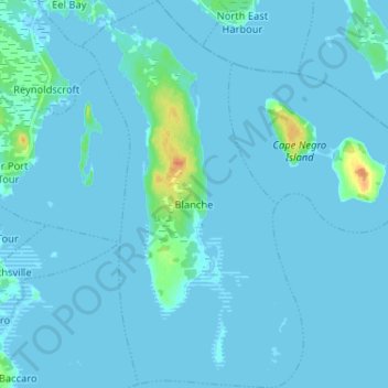
Name: Blanche topographic map, elevation, terrain.
Average elevation: 7 ft
Minimum elevation: -3 ft
Maximum elevation: 112 ft
Other topographic maps
Click on a map to view its topography, its elevation and its terrain.
Barrington Passage
Canada > Nova Scotia > Shelburne County
Barrington Passage, Municipality of the District of Barrington, Shelburne County, Nova Scotia, B0W 1E0, Canada
Average elevation: 43 ft
Central Woods Harbour
Canada > Nova Scotia > Shelburne County
Central Woods Harbour, Municipality of the District of Barrington, Shelburne County, Nova Scotia, Canada
Average elevation: 39 ft
Lower Shag Harbour
Canada > Nova Scotia > Shelburne County
Lower Shag Harbour, Municipality of the District of Barrington, Shelburne County, Nova Scotia, B0W 3B0, Canada
Average elevation: 26 ft
Sandy Point
Canada > Nova Scotia > Shelburne County
Sandy Point, Municipality of the District of Shelburne, Shelburne County, Nova Scotia, B0T 1W0, Canada
Average elevation: 75 ft
Stoney Island
Canada > Nova Scotia > Shelburne County
Stoney Island, Municipality of the District of Barrington, Shelburne County, Nova Scotia, B0W 1P0, Canada
Average elevation: 10 ft
Cape Sable Island
Canada > Nova Scotia > Shelburne County > Clark's Harbour > Newellton
Cape Sable Island, Clark's Harbour, Newellton, Municipality of the District of Barrington, Shelburne County, Nova Scotia, B0W 1P0, Canada
Average elevation: 10 ft
Shelburne
Canada > Nova Scotia > Shelburne County > Shelburne
Shelburne, Town of Shelburne, Shelburne County, Nova Scotia, Canada
Average elevation: 92 ft
Barrington West
Canada > Nova Scotia > Shelburne County
Barrington West, Municipality of the District of Barrington, Shelburne County, Nova Scotia, B0W 1E0, Canada
Average elevation: 43 ft
Town of Shelburne
Canada > Nova Scotia > Shelburne County
Town of Shelburne, Shelburne County, Nova Scotia, Canada
Average elevation: 95 ft
North East Harbour
Canada > Nova Scotia > Shelburne County
North East Harbour, Municipality of the District of Shelburne, Shelburne County, Nova Scotia, B0T 1W0, Canada
Average elevation: 20 ft
Town of Clark's Harbour
Canada > Nova Scotia > Shelburne County
Town of Clark's Harbour, Shelburne County, Nova Scotia, Canada
Average elevation: 7 ft
Wallace Lake
Canada > Nova Scotia > Shelburne County > Moosehead Island
Wallace Lake, Moosehead Island, Municipality of the District of Shelburne, Shelburne County, Nova Scotia, Canada
Average elevation: 335 ft
West Green Harbour
Canada > Nova Scotia > Shelburne County
West Green Harbour, Municipality of the District of Shelburne, Shelburne County, Nova Scotia, B0T 1L0, Canada
Average elevation: 33 ft
West Middle Sable
Canada > Nova Scotia > Shelburne County > West Middle Sable
West Middle Sable, Municipality of the District of Shelburne, Shelburne County, Nova Scotia, B0T 1V0, Canada
Average elevation: 62 ft
Little Harbour
Canada > Nova Scotia > Shelburne County
Little Harbour, Municipality of the District of Shelburne, Shelburne County, Nova Scotia, Canada
Average elevation: 10 ft
Shag Harbour
Canada > Nova Scotia > Shelburne County > Shag Harbour
Shag Harbour, Municipality of the District of Barrington, Shelburne County, Nova Scotia, B0W 3B0, Canada
Average elevation: 10 ft
Woodlawn
Canada > Nova Scotia > Shelburne County > Woodlawn
Woodlawn, Municipality of the District of Shelburne, Shelburne County, Nova Scotia, B0T 1W0, Canada
Average elevation: 141 ft
Canada Hill
Canada > Nova Scotia > Shelburne County > Canada Hill
Canada Hill, Municipality of the District of Shelburne, Shelburne County, Nova Scotia, B0T 1L0, Canada
Average elevation: 112 ft
Sable River
Canada > Nova Scotia > Shelburne County
Sable River, Municipality of the District of Shelburne, Shelburne County, Nova Scotia, B0T 1J0, Canada
Average elevation: 164 ft
Lockeport
Canada > Nova Scotia > Shelburne County > Lockeport
Lockeport, Town of Lockeport, Shelburne County, Nova Scotia, B0T 1L0, Canada
Average elevation: 23 ft
Jordan Bay
Canada > Nova Scotia > Shelburne County
Jordan Bay, Municipality of the District of Shelburne, Shelburne County, Nova Scotia, B0T 1W0, Canada
Average elevation: 46 ft
Port Saxon
Canada > Nova Scotia > Shelburne County > Port Saxon
Port Saxon, Municipality of the District of Shelburne, Shelburne County, Nova Scotia, B0T 1W0, Canada
Average elevation: 33 ft
Johns Island
Canada > Nova Scotia > Shelburne County > Forbes Point
Johns Island, Forbes Point, Municipality of the District of Barrington, Shelburne County, Nova Scotia, B0W 2A0, Canada
Average elevation: 33 ft
North East Point
Canada > Nova Scotia > Shelburne County > North East Point
North East Point, Municipality of the District of Barrington, Shelburne County, Nova Scotia, B0W 1P0, Canada
Average elevation: 16 ft
Jordan Ferry
Canada > Nova Scotia > Shelburne County
Jordan Ferry, Municipality of the District of Shelburne, Shelburne County, Nova Scotia, B0T 1W0, Canada
Average elevation: 72 ft
Atlantic
Canada > Nova Scotia > Shelburne County
Atlantic, Municipality of the District of Shelburne, Shelburne County, Nova Scotia, B0T 1W0, Canada
Average elevation: 20 ft
Jordan Falls
Canada > Nova Scotia > Shelburne County
Jordan Falls, Municipality of the District of Shelburne, Shelburne County, Nova Scotia, B0T 1L0, Canada
Average elevation: 217 ft
Barrington
Canada > Nova Scotia > Shelburne County > Barrington
Barrington, Municipality of the District of Barrington, Shelburne County, Nova Scotia, Canada
Average elevation: 75 ft