
Finley topographic map
Click on the map to display elevation.
About this map
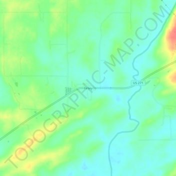
Name: Finley topographic map, elevation, terrain.
Location: Finley, Pushmataha County, Oklahoma, 74543, United States (34.30843 -95.51497 34.34843 -95.47497)
Average elevation: 509 ft
Minimum elevation: 449 ft
Maximum elevation: 627 ft
Other topographic maps
Click on a map to view its topography, its elevation and its terrain.
Clayton
United States > Oklahoma > Pushmataha County
Clayton, located in the Kiamichi River valley, is framed on its west by Flagpole Mountain (1,562 ft.) and to its east by unnamed mountains topping 1,600 feet in elevation. Within a few miles of Clayton is scenic McKinley Rocks, a collection of massive boulders strewn across a mountain top. South of Clayton is…
Average elevation: 617 ft