Geolocate

Paris topographic map

Click on the map to display elevation.

About this map

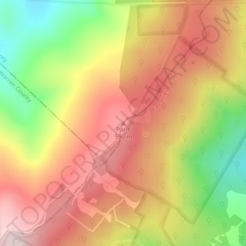
Name: Paris topographic map, elevation, terrain.

Location: Paris, Fauquier County, Virginia, United States (38.98388 -78.00159 38.98398 -78.00149)

Average elevation: 1,542 ft

Minimum elevation: 856 ft

Maximum elevation: 2,064 ft

Fauquier County trails, hiking, mountain biking, running and outdoor activities

Other topographic maps

Click on a map to view its topography, its elevation and its terrain.

Bealeton

United States > Virginia > Fauquier County > Bealeton

Average elevation: 328 ft

Marshall

United States > Virginia > Fauquier County

Average elevation: 620 ft

New Baltimore

United States > Virginia > Fauquier County

Average elevation: 486 ft

Rectortown

United States > Virginia > Fauquier County

Average elevation: 528 ft

Upperville

United States > Virginia > Fauquier County

Average elevation: 564 ft

Broad Run

United States > Virginia > Fauquier County > Broad Run

Average elevation: 538 ft

Gear up for your next adventure:

🛠️Backpacking Tool Kit - Essential toolkit for outdoor repairs
🖼️Topo Map Wall Art - Decorative topographic prints of famous peaks and regions
📦Dry Bags Set - Waterproof storage for electronics and clothes
🦟Ultrasonic Repellers - Create a bug-free zone at your camp or rest stop
🍳Camping Cook Set - Complete cookware for outdoor meals

As an Amazon Associate, this site earns from qualifying purchases at no extra cost to you.