Geolocate

Mailimoja topographic map

Click on the map to display elevation.

About this map

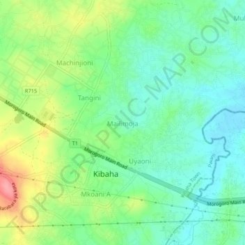
Name: Mailimoja topographic map, elevation, terrain.

Location: Mailimoja, Kibaha Town, Pwani Region, Coastal Zone, Tanzania (-6.79810 38.97478 -6.75810 39.01478)

Average elevation: 427 ft

Minimum elevation: 318 ft

Maximum elevation: 636 ft

Other topographic maps

Click on a map to view its topography, its elevation and its terrain.

Mkuranga

Tanzania > Pwani Region

Average elevation: 292 ft

Kisarawe

Tanzania > Pwani Region

Average elevation: 443 ft

Mkuranga

Tanzania > Pwani Region

Average elevation: 292 ft

Rufiji

Tanzania > Pwani Region

Average elevation: 180 ft

Rufiji

Tanzania > Pwani Region

Average elevation: 577 ft

Mkuranga

Tanzania > Pwani Region

Average elevation: 292 ft

ruvu river

Tanzania > Pwani Region

Average elevation: 338 ft

Mafia Island

Tanzania > Pwani Region

Average elevation: 13 ft

Rufiji

Tanzania > Pwani Region

Average elevation: 577 ft

Gear up for your next adventure:

📶Satellite Messenger - Communication device off‑grid
🪶Paracord Bracelet - Survival bracelet with built‑in tools
🪑Ultralight Camp Chairs - Portable seating for resting after a long day of mapping
🥇GPS Hiking Watch - Multi‑sport GPS watch with navigation and trail tracking
📷Action Cameras - Rugged cameras to document your journeys across rugged terrain

As an Amazon Associate, this site earns from qualifying purchases at no extra cost to you.