
Constanza topographic map
Click on the map to display elevation.
Constanza
The town of Constanza is located at a height of 1220 meters (4000 ft) above sea level in the middle of the Cordillera Central (Central Range), the tallest mountain range in the island of Hispaniola and the entire Caribbean region. The annual average temperatures range from 41 °F (5 °C) to 68 °F (20 °C), depending on altitude. The valley is 8 km long and 4 km wide.
About this map
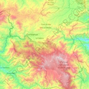
Name: Constanza topographic map, elevation, terrain.
Location: Constanza, La Vega, Dominican Republic (18.68450 -70.87020 19.04567 -70.51444)
Average elevation: 4,833 ft
Minimum elevation: 1,463 ft
Maximum elevation: 9,229 ft
Other topographic maps
Click on a map to view its topography, its elevation and its terrain.