Geolocate

Clifty topographic map

Click on the map to display elevation.

About this map

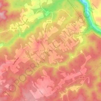
Name: Clifty topographic map, elevation, terrain.

Location: Clifty, Fayette County, West Virginia, 25854, United States (38.12567 -80.98204 38.16567 -80.94204)

Average elevation: 1,932 ft

Minimum elevation: 1,444 ft

Maximum elevation: 2,146 ft

Fayette County trails, hiking, mountain biking, running and outdoor activities

Other topographic maps

Click on a map to view its topography, its elevation and its terrain.

Ansted

United States > West Virginia > Fayette County

Average elevation: 1,572 ft

Powellton

United States > West Virginia > Fayette County

Average elevation: 1,552 ft

Smithers

United States > West Virginia > Fayette County

Average elevation: 1,119 ft

Montgomery

United States > West Virginia > Fayette County

Average elevation: 1,106 ft

Pax

United States > West Virginia > Fayette County

Average elevation: 1,821 ft

Gear up for your next adventure:

⛑️Personal Locator Beacon - Safety beacon for emergencies
🪓Survival Multi‑Tool - Versatile tool for camp and trail tasks
🌡️Portable Weather Meter - Track weather conditions on the trail
🥾Women's Hiking Boots - Top-rated trail boots with ankle support and superior grip
🍳Camping Cook Set - Complete cookware for outdoor meals

As an Amazon Associate, this site earns from qualifying purchases at no extra cost to you.