
Make a donation
Gear up for your next adventure:
As an Amazon Associate, this site earns from qualifying purchases at no extra cost to you.
Oberfrauendorf topographic map
Click on the map to display elevation.
Make a donation
Gear up for your next adventure:
As an Amazon Associate, this site earns from qualifying purchases at no extra cost to you.
Oberfrauendorf
Angelegt ist Oberfrauendorf als Waldhufendorf entlang eines in den höheren Lagen entspringenden Baches, dem Grimmschen Wasser (benannt nach Reinhardtsgrimma) oder Lockwitzbach. Dieser Bach fließt in nördliche Richtung um in Dresden-Laubegast in die Elbe zu münden.
Make a donation
Gear up for your next adventure:
As an Amazon Associate, this site earns from qualifying purchases at no extra cost to you.
About this map
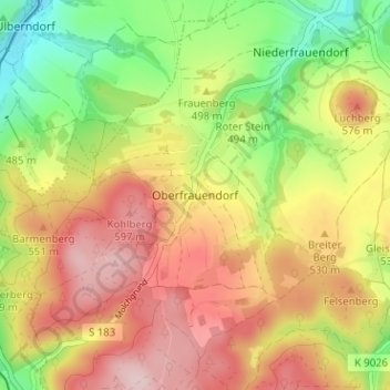
Name: Oberfrauendorf topographic map, elevation, terrain.
Average elevation: 1,654 ft
Minimum elevation: 1,217 ft
Maximum elevation: 2,060 ft
Make a donation
Gear up for your next adventure:
As an Amazon Associate, this site earns from qualifying purchases at no extra cost to you.