
Make a donation
Gear up for your next adventure:
As an Amazon Associate, this site earns from qualifying purchases at no extra cost to you.
Gamewell topographic map
Click on the map to display elevation.
Make a donation
Gear up for your next adventure:
As an Amazon Associate, this site earns from qualifying purchases at no extra cost to you.
About this map
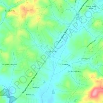
Name: Gamewell topographic map, elevation, terrain.
Location: Gamewell, Caldwell County, North Carolina, United States (35.84930 -81.61621 35.88930 -81.57621)
Average elevation: 1,125 ft
Minimum elevation: 1,014 ft
Maximum elevation: 1,394 ft
Caldwell County trails, hiking, mountain biking, running and outdoor activities
Make a donation
Gear up for your next adventure:
As an Amazon Associate, this site earns from qualifying purchases at no extra cost to you.
Other topographic maps
Click on a map to view its topography, its elevation and its terrain.
Cajah's Mountain
United States > North Carolina > Caldwell County
Cajah's Mountain is located in southern Caldwell County. It is bordered to the north by Lenoir, the county seat. Cajah Mountain's highest elevation 1,530 feet (470 m), is at the southern end of the town next to Connelly Springs Road, the major north–south road through the town.
Average elevation: 1,280 ft
Make a donation
Gear up for your next adventure:
As an Amazon Associate, this site earns from qualifying purchases at no extra cost to you.