
Thank you for supporting this site ❤️
Make a donation
Make a donation
Gear up for your next adventure:
As an Amazon Associate, this site earns from qualifying purchases at no extra cost to you.
Vincent topographic map
Click on the map to display elevation.
Thank you for supporting this site ❤️
Make a donation
Make a donation
Gear up for your next adventure:
As an Amazon Associate, this site earns from qualifying purchases at no extra cost to you.
About this map
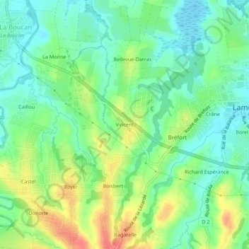
Name: Vincent topographic map, elevation, terrain.
Location: Vincent, Lamentin, Basse-Terre, Guadeloupe, 97129, France (16.24757 -61.67121 16.28757 -61.63121)
Average elevation: 85 ft
Minimum elevation: 7 ft
Maximum elevation: 223 ft
Thank you for supporting this site ❤️
Make a donation
Make a donation
Gear up for your next adventure:
As an Amazon Associate, this site earns from qualifying purchases at no extra cost to you.