
Heppignies topographic map
Interactive map
Click on the map to display elevation.
About this map
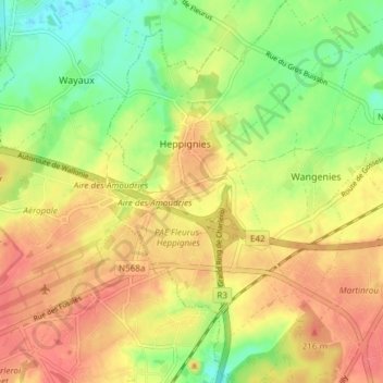
Name: Heppignies topographic map, elevation, terrain.
Location: Heppignies, Fleurus, Charleroi, Hainaut, Wallonie, Belgique (50.45190 4.47821 50.49949 4.52431)
Average elevation: 525 ft
Minimum elevation: 417 ft
Maximum elevation: 614 ft
Other topographic maps
Click on a map to view its topography, its elevation and its terrain.