
Make a donation
Gear up for your next adventure:
As an Amazon Associate, this site earns from qualifying purchases at no extra cost to you.
Beninksberg topographic map
Click on the map to display elevation.
Make a donation
Gear up for your next adventure:
As an Amazon Associate, this site earns from qualifying purchases at no extra cost to you.
About this map
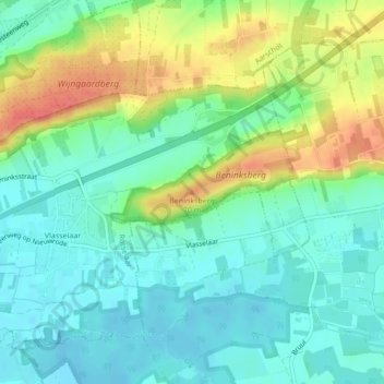
Name: Beninksberg topographic map, elevation, terrain.
Average elevation: 105 ft
Minimum elevation: 36 ft
Maximum elevation: 236 ft
Make a donation
Gear up for your next adventure:
As an Amazon Associate, this site earns from qualifying purchases at no extra cost to you.
Other topographic maps
Click on a map to view its topography, its elevation and its terrain.
Werchter
België > Vlaams-Brabant > Leuven > Rotselaar
Werchter ligt aan de samenvloeiing van Demer en Dijle. In het noorden stroomt de Laak. De hoogte van Werchter bedraagt 10-15 meter. De bodem bestaat uit zand.
Average elevation: 33 ft
Wezemaal
België > Vlaams-Brabant > Leuven > Rotselaar
In de 15de eeuw groeide Wezemaal uit tot het belangrijkste bedevaartsoord van Sint-Job in de Nederlanden. De bedevaart bereikte een hoogtepunt tussen 1496 en ca. 1520, als gevolg van de grote syfilisepidemie die Europa vanaf 1496 teisterde. Rond 1515 trokken minstens 23.000 bedevaarders naar Wezemaal. Van de…
Average elevation: 62 ft
Make a donation
Gear up for your next adventure:
As an Amazon Associate, this site earns from qualifying purchases at no extra cost to you.