Geolocate

Richardsville topographic map

Interactive map

Click on the map to display elevation.

About this map

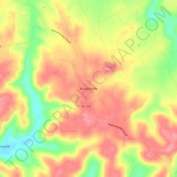
Name: Richardsville topographic map, elevation, terrain.

Location: Richardsville, Warren County, Kentucky, United States (37.08477 -86.49082 37.12477 -86.45082)

Average elevation: 597 ft

Minimum elevation: 407 ft

Maximum elevation: 719 ft

Other topographic maps

Click on a map to view its topography, its elevation and its terrain.

Bowling Green

United States > Kentucky > Warren County

Bowling Green, Warren County, Kentucky, 42101, United States

Average elevation: 554 ft

Rockfield

United States > Kentucky > Warren County

Rockfield, Warren County, Kentucky, 42274, United States

Average elevation: 587 ft

Plano

United States > Kentucky > Warren County

Plano, Warren County, Kentucky, 42102, United States

Average elevation: 597 ft

Alvaton

United States > Kentucky > Warren County

Alvaton, Warren County, Kentucky, 42122, United States

Average elevation: 597 ft

Smiths Grove

United States > Kentucky > Warren County

Smiths Grove, Warren County, Kentucky, United States

Average elevation: 633 ft

Springhill

United States > Kentucky > Warren County > Bowling Green > Springhill

Springhill, Bowling Green, Warren County, Kentucky, 42101-1000, United States

Average elevation: 509 ft