
Make a donation
Gear up for your next adventure:
As an Amazon Associate, this site earns from qualifying purchases at no extra cost to you.
Itteren topographic map
Click on the map to display elevation.
Make a donation
Gear up for your next adventure:
As an Amazon Associate, this site earns from qualifying purchases at no extra cost to you.
Itteren
Itteren ligt op de rechteroever van de Maas, op een hoogte van ongeveer 43 meter. Het ligt sinds de aanleg van het Julianakanaal omstreeks 1930 op een langgerekt eiland, door enkele bruggen met het achterland verbonden.
Make a donation
Gear up for your next adventure:
As an Amazon Associate, this site earns from qualifying purchases at no extra cost to you.
About this map
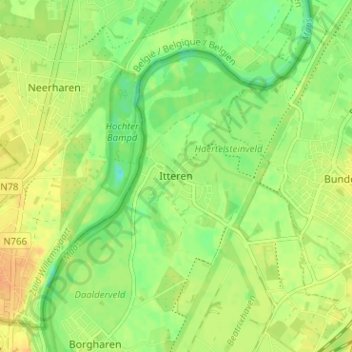
Name: Itteren topographic map, elevation, terrain.
Location: Itteren, Maastricht, Limburg, Nederland, 6223 GN, Nederland (50.87773 5.68293 50.91773 5.72293)
Average elevation: 151 ft
Minimum elevation: 95 ft
Maximum elevation: 197 ft
Make a donation
Gear up for your next adventure:
As an Amazon Associate, this site earns from qualifying purchases at no extra cost to you.