Geolocate

Sullington topographic map

Click on the map to display elevation.

About this map

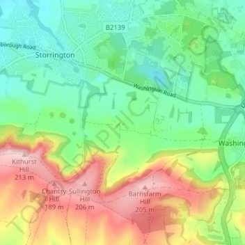
Name: Sullington topographic map, elevation, terrain.

Location: Sullington, Storrington and Sullington, Storrington, Horsham, West Sussex, England, RH20 4AE, United Kingdom (50.88734 -0.45807 50.92734 -0.41807)

Average elevation: 305 ft

Minimum elevation: 72 ft

Maximum elevation: 686 ft

Other topographic maps

Click on a map to view its topography, its elevation and its terrain.

Gear up for your next adventure:

😴Insulated Sleeping Pads - Compact and warm pads for high-elevation camping
👟Men's Trail Runners - Lightweight footwear for fast-paced exploration and light hiking
🦟Ultrasonic Repellers - Create a bug-free zone at your camp or rest stop
🧤Hiking Gloves - Protective gloves for rugged trails
📱Heavy-Duty Phone Cases - Drop-proof and waterproof protection for outdoor navigation

As an Amazon Associate, this site earns from qualifying purchases at no extra cost to you.