
Make a donation
Gear up for your next adventure:
As an Amazon Associate, this site earns from qualifying purchases at no extra cost to you.
Parque de la Vida Saludable topographic map
Click on the map to display elevation.
Make a donation
Gear up for your next adventure:
As an Amazon Associate, this site earns from qualifying purchases at no extra cost to you.
About this map
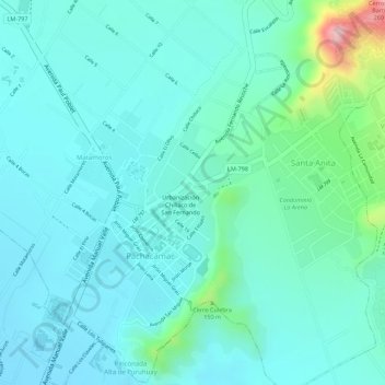
Name: Parque de la Vida Saludable topographic map, elevation, terrain.
Average elevation: 302 ft
Minimum elevation: 157 ft
Maximum elevation: 909 ft
Make a donation
Gear up for your next adventure:
As an Amazon Associate, this site earns from qualifying purchases at no extra cost to you.
Other topographic maps
Click on a map to view its topography, its elevation and its terrain.
Make a donation
Gear up for your next adventure:
As an Amazon Associate, this site earns from qualifying purchases at no extra cost to you.
Make a donation
Gear up for your next adventure:
As an Amazon Associate, this site earns from qualifying purchases at no extra cost to you.
Pachacámac
Perú > Lima > Lima Metropolitana
El distrito de Pachacámac está ubicado en Lima Sur. Cuenta con una superficie de 160.23 km² y su altitud media es de 73 m s.n.m.
Average elevation: 2,290 ft
Make a donation
Gear up for your next adventure:
As an Amazon Associate, this site earns from qualifying purchases at no extra cost to you.