
Lake Cowichan topographic map
Interactive map
Click on the map to display elevation.
About this map
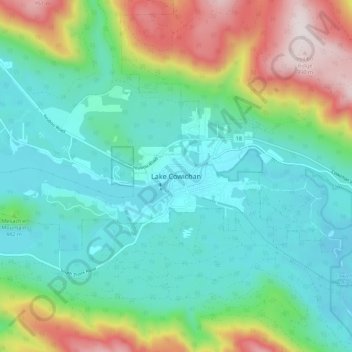
Name: Lake Cowichan topographic map, elevation, terrain.
Average elevation: 1,240 ft
Minimum elevation: 463 ft
Maximum elevation: 3,291 ft
Other topographic maps
Click on a map to view its topography, its elevation and its terrain.
Area F (Cowichan Lake South / Skutz Falls)
Canada > British Columbia > Cowichan Valley Regional District
Area F (Cowichan Lake South / Skutz Falls), Cowichan Valley Regional District, British Columbia, Canada
Average elevation: 896 ft
Duncan
Canada > British Columbia > Cowichan Valley Regional District > Duncan > Duncan
Duncan, Cowichan Valley Regional District, British Columbia, V9L 1W3, Canada
Average elevation: 157 ft