
Make a donation
Gear up for your next adventure:
As an Amazon Associate, this site earns from qualifying purchases at no extra cost to you.
Malangas topographic map
Click on the map to display elevation.
Make a donation
Gear up for your next adventure:
As an Amazon Associate, this site earns from qualifying purchases at no extra cost to you.
Malangas
Malangas also includes the island of Muyong, having endowed with white sand beaches, and other of uninhabited islands near the shorelines. Mainland area are steeply sloping terrain of hills and mountains. Due to its topography and elevation the town do not experience flooding.
Make a donation
Gear up for your next adventure:
As an Amazon Associate, this site earns from qualifying purchases at no extra cost to you.
About this map
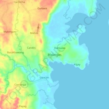
Name: Malangas topographic map, elevation, terrain.
Average elevation: 125 ft
Minimum elevation: -13 ft
Maximum elevation: 564 ft
Make a donation
Gear up for your next adventure:
As an Amazon Associate, this site earns from qualifying purchases at no extra cost to you.
Other topographic maps
Click on a map to view its topography, its elevation and its terrain.