
Make a donation
Gear up for your next adventure:
As an Amazon Associate, this site earns from qualifying purchases at no extra cost to you.
Alameda topographic map
Click on the map to display elevation.
Make a donation
Gear up for your next adventure:
As an Amazon Associate, this site earns from qualifying purchases at no extra cost to you.
About this map
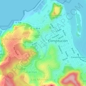
Name: Alameda topographic map, elevation, terrain.
Average elevation: 151 ft
Minimum elevation: -3 ft
Maximum elevation: 505 ft
Make a donation
Gear up for your next adventure:
As an Amazon Associate, this site earns from qualifying purchases at no extra cost to you.
Other topographic maps
Click on a map to view its topography, its elevation and its terrain.
Las Pitras
Chile > Región del Maule > Provincia de Talca > Constitución > San Ramón
Average elevation: 1,263 ft
Las Corrientes
Chile > Región del Maule > Provincia de Talca > Constitución
Average elevation: 1,014 ft
Make a donation
Gear up for your next adventure:
As an Amazon Associate, this site earns from qualifying purchases at no extra cost to you.
Coipué
Chile > Región del Maule > Provincia de Talca > Constitución > Coipué
Average elevation: 325 ft