
Schreiber topographic map
Interactive map
Click on the map to display elevation.
About this map
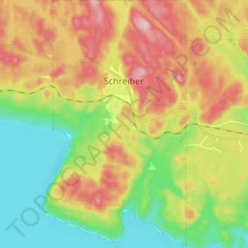
Name: Schreiber topographic map, elevation, terrain.
Average elevation: 978 ft
Minimum elevation: 568 ft
Maximum elevation: 1,522 ft
Schreiber, despite being in a bowl, sits higher than the surrounding area. The village of Rossport, sitting on Lake Superior, 14 mi (23 km) to the west, has an elevation of 630 ft (190 m) above sea level. Jackfish, the historic townsite to the east, also sits at 630 ft (190 m) above sea level. Terrace Bay, situated between Schreiber and Jackfish, is located at 889 ft (271 m) feet above sea level. Schreiber itself, at its centre, is shown as being at 988 ft (301 m) above sea level.