Geolocate

Tangcarang topographic map

Click on the map to display elevation.

About this map

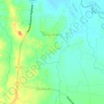
Name: Tangcarang topographic map, elevation, terrain.

Location: Tangcarang, Alaminos, Pangasinan, Ilocos Region, Philippines (16.09691 119.96792 16.11701 119.99892)

Average elevation: 75 ft

Minimum elevation: 36 ft

Maximum elevation: 141 ft

Other topographic maps

Click on a map to view its topography, its elevation and its terrain.

Alaminos

Philippines > Pangasinan > Alaminos

Average elevation: 144 ft

Hundred Islands

Philippines > Pangasinan > Alaminos

Average elevation: 3 ft

Hundred Islands

Philippines > Pangasinan > Alaminos

Average elevation: 3 ft

Gear up for your next adventure:

🌲Outdoor Survival Books - Best books on survival skills
📦Gear Storage Bags - Organize and protect outdoor equipment
🛶Inflatable Kayak - Portable kayak for rivers, lakes, and expeditions
📷Action Cameras - Rugged cameras to document your journeys across rugged terrain
🌐World Map Poster - Decorative world maps with topographic info

As an Amazon Associate, this site earns from qualifying purchases at no extra cost to you.