Geolocate

Fleming Key topographic map

Click on the map to display elevation.

About this map

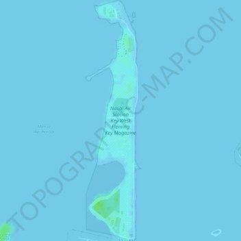
Name: Fleming Key topographic map, elevation, terrain.

Location: Fleming Key, Key West, Monroe County, Florida, United States (24.56739 -81.80075 24.59472 -81.79383)

Average elevation: 0 ft

Minimum elevation: -3 ft

Maximum elevation: 33 ft

Monroe County trails, hiking, mountain biking, running and outdoor activities

Other topographic maps

Click on a map to view its topography, its elevation and its terrain.

Sunset Key

United States > Florida > Monroe County > Key West

Average elevation: 3 ft

Gear up for your next adventure:

🎒Day Hiking Backpack - Lightweight backpack perfect for day trips and outdoor adventures
🎒Outdoor Daypacks - Lightweight backpacks designed for carrying maps and essential gear
🪶Paracord Bracelet - Survival bracelet with built‑in tools
🖼️Topo Map Wall Art - Decorative topographic prints of famous peaks and regions
🔋Solar Power Banks - Keep your GPS and phone charged in remote wilderness areas

As an Amazon Associate, this site earns from qualifying purchases at no extra cost to you.