Geolocate

Sunset Key topographic map

Click on the map to display elevation.

About this map

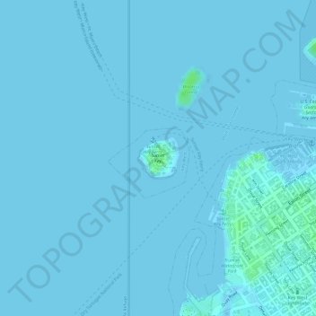
Name: Sunset Key topographic map, elevation, terrain.

Location: Sunset Key, Truman Annex1, Key West, Monroe County, Florida, United States (24.56022 -81.81592 24.56379 -81.81198)

Average elevation: 3 ft

Minimum elevation: -7 ft

Maximum elevation: 30 ft

Monroe County trails, hiking, mountain biking, running and outdoor activities

Other topographic maps

Click on a map to view its topography, its elevation and its terrain.

Stock Island

United States > Florida > Monroe County > Key West

Average elevation: 3 ft

Fleming Key

United States > Florida > Monroe County > Key West

Average elevation: 0 ft

Fleming Key

United States > Florida > Monroe County > Key West

Average elevation: 0 ft

Gear up for your next adventure:

🔋Solar Power Banks - Keep your GPS and phone charged in remote wilderness areas
🪶Thermal Camp Blanket - Extra warmth for cold nights
📷Action Cameras - Rugged cameras to document your journeys across rugged terrain
🪑Ultralight Camp Chairs - Portable seating for resting after a long day of mapping
GPS Sports Watch - GPS watch for running, hiking and training

As an Amazon Associate, this site earns from qualifying purchases at no extra cost to you.