Geolocate

Superga topographic map

Click on the map to display elevation.

About this map

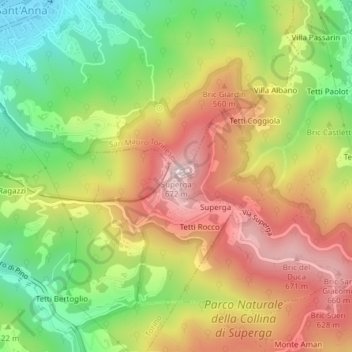
Name: Superga topographic map, elevation, terrain.

Location: Superga, Torino, Piemonte, 10099, Italia (45.08046 7.76705 45.08056 7.76715)

Average elevation: 1,463 ft

Minimum elevation: 689 ft

Maximum elevation: 2,254 ft

Other topographic maps

Click on a map to view its topography, its elevation and its terrain.

Mirafiori Sud

Italia > Piemonte > Torino > Torino

Average elevation: 804 ft

Parco del Valentino

Italia > Piemonte > Torino > Torino

Average elevation: 883 ft

Circoscrizione 1

Italia > Piemonte > Torino > Torino

Average elevation: 833 ft

Parco del Valentino

Italia > Piemonte > Torino > Torino

Average elevation: 883 ft

Mirafiori Sud

Italia > Piemonte > Torino > Torino

Average elevation: 804 ft

Parco Dora (area Michelin)

Italia > Piemonte > Torino > Torino

Average elevation: 817 ft

Gear up for your next adventure:

🩳Quick‑Dry Hiking Shorts - Comfortable and quick‑dry shorts for summer hiking
📖Nature Tracking Books - Learn to track wildlife and terrain
🎒Waterproof Dry Bags - Keep your electronics and maps dry inside your pack
🧭Orienteering Set - Complete compass and map reading kit
🧯Portable Fire Pit - Compact fire pit for camping spots

As an Amazon Associate, this site earns from qualifying purchases at no extra cost to you.