Geolocate

Godinne topographic map

Click on the map to display elevation.

About this map
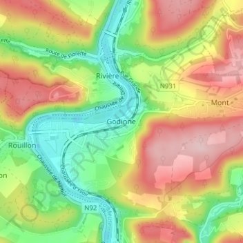
Name: Godinne topographic map, elevation, terrain.

Location: Godinne, Yvoir, Dinant, Province de Namur, Wallonie, 5530, Belgique (50.33053 4.85599 50.37053 4.89599)

Average elevation: 571 ft

Minimum elevation: 243 ft

Maximum elevation: 942 ft

Other topographic maps

Click on a map to view its topography, its elevation and its terrain.

Rochefort

Belgique > Province de Namur > Dinant

Average elevation: 735 ft

Buissonville

Belgique > Province de Namur > Dinant

Average elevation: 784 ft

Ciney

Belgique > Province de Namur > Dinant

Average elevation: 876 ft

Vresse-sur-Semois

Belgique > Province de Namur > Dinant

Vresse-sur-Semois, située dans la province de Namur, en Wallonie, est un village ardennais situé à environ 180 mètres d'altitude, niché sur la rive droite de la sinueuse Semois, à sa confluence avec le ruisseau de Ruaumoulin. Le village est particulièrement marqué par son terrain accidenté, où la…

Average elevation: 1,076 ft

Han-sur-Lesse

Belgique > Province de Namur > Dinant

Average elevation: 636 ft

Naomé

Belgique > Province de Namur > Dinant

Average elevation: 1,283 ft

Bièvre

Belgique > Province de Namur > Dinant

Average elevation: 1,217 ft

Gear up for your next adventure:

⌚GPS Sports Watch - GPS watch for running, hiking and training
📦Dry Bags Set - Waterproof storage for electronics and clothes
⌚Solar GPS Watches - Advanced multisport watches with built-in topographic maps
🥤Water Filter Bottle - All‑in‑one filter bottle for safe hydration
🏫Relief Map Kits - Hands-on tools for teaching landforms and elevation

As an Amazon Associate, this site earns from qualifying purchases at no extra cost to you.