
Make a donation
Gear up for your next adventure:
As an Amazon Associate, this site earns from qualifying purchases at no extra cost to you.
Langhecke topographic map
Click on the map to display elevation.
Make a donation
Gear up for your next adventure:
As an Amazon Associate, this site earns from qualifying purchases at no extra cost to you.
Langhecke
Der Ort selbst liegt auf etwa 240 Metern Höhe und verläuft als Straßendorf sichelförmig gestreckt in einem von Osten nach Nordwesten verlaufenden Tal des Dernbachs. Höchste Erhebung ist der 303 Meter hohe Schulberg nordöstlich des Dorfs. Insgesamt ist die Gemarkung von steil aufragenden Höhenzügen in unmittelbarem Anschluss an das Dorf geprägt. Der überwiegende Teil der Gemarkung ist von Mischwald bedeckt. Lediglich östlich des Orts befinden sich einige landwirtschaftlich genutzte Wiesen. Ackerfläche ist kaum vorhanden. Eine ehemalige Schiefergrube nordwestlich des Orts prägt das Landschaftsbild.
Make a donation
Gear up for your next adventure:
As an Amazon Associate, this site earns from qualifying purchases at no extra cost to you.
About this map
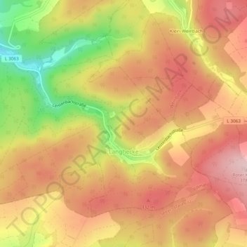
Name: Langhecke topographic map, elevation, terrain.
Average elevation: 932 ft
Minimum elevation: 463 ft
Maximum elevation: 1,227 ft
Make a donation
Gear up for your next adventure:
As an Amazon Associate, this site earns from qualifying purchases at no extra cost to you.